A Town Most La Fortuna Itineraries Skip — On Purpose
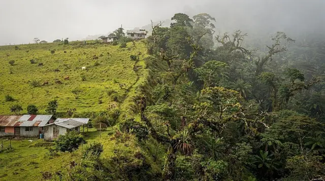
Upala doesn’t appear on the mental map most travelers draw of a La Fortuna trip, and that’s the right instinct. This is a working district capital in the far north of San Carlos canton, built on rice, sugarcane, and cattle, sitting close enough to the Nicaragua border that its economy and its rhythms belong to the frontier as much as to the tourist trail that runs through /destinations/la-fortuna/ and /destinations/bijagua/. There is no volcano to look at, no turquoise river, no canopy park. What there is: flat farm country, long straight roads, cattle trucks, and a small-town center that exists to serve the people who live there, not the people passing through.
That’s not a criticism — it’s the reason this page exists as a separate entry rather than a paragraph tacked onto Bijagua or Guatuso. Upala is genuinely peripheral to an Arenal-centered stay, and a guide that pretends otherwise sets you up for a wasted afternoon. If your trip is built around the volcano, the hot springs, and the hanging bridges, skip this page and this town. If you’re building something bigger — a loop that pushes past /destinations/rio-celeste/ and /destinations/cano-negro/ toward the northern border region — keep reading, because that’s the only context in which Upala earns a place on the map.
Getting There From La Fortuna
There is no direct highway between La Fortuna and Upala. The practical route runs through /destinations/guatuso/, on rural roads that are mostly paved but narrow, with a steady sequence of one-lane bridges where the vehicle facing the CEDA EL PASO sign yields. Expect 1h45 to 2h15 depending on where in La Fortuna you start and how much farm traffic you meet along the way.
| From | Distance | Drive time | Road notes |
|---|---|---|---|
| La Fortuna town center | ~75 km | 1h45–2h15 | Paved but narrow, several one-lane bridges |
| Bijagua | ~35 km | 45min–1h | Shorter, still rural two-lane roads |
| Ciudad Quesada | ~55 km | 1h15–1h30 | Main regional connector road |
| Caño Negro | ~45 km | 1h–1h20 | Partly unpaved near the wetland access |
A rental car is the only realistic way to do this comfortably — see /guides/renting-a-car-for-la-fortuna/ for what that actually involves in this part of the country, and /blog/should-you-rent-a-4x4-here/ for an honest answer on whether you need four-wheel drive for roads like these (mostly no, in dry season; it helps in green season). If you’d rather not self-drive the whole stretch, a transfer service that already routes through this corridor can simplify things — one option covers the leg from San José with a stop at a wildlife sanctuary along the way:
this San José–Upala transfer with a stop at the Las Pumas wildlife sanctuary saves you the navigation decisions on a route with very little signage and even less cell coverage.
There is no meaningful public shuttle network built for tourists on this route. Local buses exist, connecting Upala to /destinations/ciudad-quesada/ and to the border communities, but they run on local schedules aimed at residents, not visitors with a return flight to catch.
What Upala Is — And What It Isn’t
Upala is the seat of its own canton, with a population in the low tens of thousands spread across town and the surrounding farm villages. The center has a central park, a church, a public market, a scatter of sodas serving casados and coffee, and the everyday commerce of a regional hub: hardware stores, farm-supply shops, a bus terminal. None of it is dressed up for tourism, and that’s exactly the point — this is what an ordinary Costa Rican farming town looks like without a volcano or a beach nearby to reshape it.
What Upala is not: a base for exploring Arenal, a stop on the way to Monteverde, or a day-trip pairing with Río Celeste. The geography doesn’t cooperate — Upala sits north and somewhat west of the /destinations/tenorio-volcano-national-park/ area, on a different road system than the one that connects La Fortuna to Bijagua and the park entrance.
Trying to combine a Río Celeste morning with an Upala afternoon usually means several extra hours of driving for very little payoff, and it’s a mistake covered in more detail in /guides/la-fortuna-vs-rio-celeste/ and in the broader planning notes at /guides/la-fortuna-travel-mistakes-to-avoid/.
If you’re weighing whether Upala belongs anywhere in your plans at all, the honest framework is this: it’s a waypoint for people already headed further north, not a destination for people centered on the volcano.
The Nicaragua Border and the Rural North
Upala’s identity is shaped by its position near the frontier. The district borders Nicaragua directly in its northern reaches, and the town functions as the commercial center for a scatter of farm communities that stretch right up to the border line. This proximity shows up in small ways — accents, produce, the occasional Nicaraguan córdoba changing hands alongside colones — more than in anything a short visit would register as dramatic.
There are minor official border crossings in this general region, but none of them are set up for the kind of casual, walk-across tourism that /destinations/liberia/ travelers might associate with the Peñas Blancas crossing on the Pacific side. If an actual border crossing is part of your plan, treat it as its own logistical project — confirm current entry requirements, opening hours, and whether the crossing you’re aiming for even processes foreign tourists, well before you build a day around it. Most visitors who pass through Upala are not crossing into Nicaragua; they’re using the town as a stopover on a longer loop through Costa Rica’s least-visited corner.
That corner includes the wetlands around /destinations/cano-negro/ and the Río Frío basin, the Maleku communities near /destinations/maleku-indigenous-reserve/, and farm country all the way to /destinations/katira/ and /destinations/guatuso/ — each with its own separate page on this site, because each is its own small decision, not an extension of the same day trip.
Nature Near Upala: What’s Actually Worth the Detour
Upala’s own town center has no natural attractions to speak of, but the district it anchors sits between two things that do: the wetlands to the east around Caño Negro, and the rainforest and cloud-forest transition zone around Bijagua and the Tenorio volcano to the south. If you’re already in the area, a coffee-and-chocolate farm tour that runs through the Bijagua–Upala corridor is a reasonable way to see the working agricultural landscape up close rather than just driving past it:
this Bijagua de Upala coffee, chocolate, and rainforest tour covers small-farm production methods that the postcard version of Costa Rica tends to skip over.
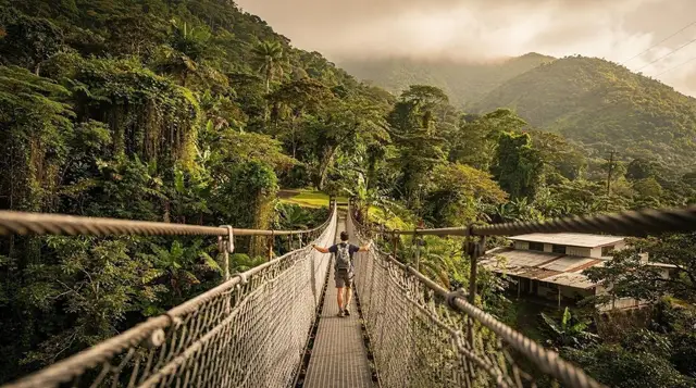
Closer to Bijagua itself, and a much shorter detour if you’re coming from La Fortuna rather than continuing on to Upala proper, the Heliconias forest reserve offers suspension bridges through a quieter, far less crowded canopy than the parks around Arenal:
this guided walk across the Heliconias hanging bridges is a low-key alternative for travelers who’ve already done the bigger bridge parks near La Fortuna and want something with fewer people on the trail.
Neither of these replaces a proper Río Celeste day — for that, see /guides/rio-celeste-day-trip-from-la-fortuna/ — but they’re honest options for the stretch of countryside between Bijagua and Upala that most itineraries drive through without stopping.
Should You Stop in Upala? A Decision Table
| Your trip | Stop in Upala? |
|---|---|
| Standard 3–5 day La Fortuna + Arenal trip | No — skip entirely |
| La Fortuna + Río Celeste + Bijagua loop | No — different road, adds hours for little return |
| Extended trip into the northern border region | Yes, as a pass-through and fuel/food stop |
| Birdwatching trip through Caño Negro and the Río Frío | Possibly — Upala is a reasonable overnight base for that specific circuit |
| Curiosity about rural, non-touristic Costa Rica | Yes, with realistic expectations |
The pattern is consistent: Upala rewards travelers who already have a reason to be in the far north, and offers little to anyone whose trip is anchored on the volcano. Planning a first visit to the region generally, rather than this specific town? Start with /guides/best-time-to-visit-la-fortuna/ and /itineraries/la-fortuna-and-rio-celeste/ before deciding whether a northward extension as far as Upala makes sense for your dates.
Practical Notes
Money. Upala runs on colones more than dollars — this is not a tourist economy with USD pricing baked in, so bring local currency or expect to use cards at the handful of places that take them. Small sodas and market stalls are cash-only.
Fuel and services. Fill up before leaving the Bijagua–Guatuso corridor if you’re continuing north of Upala; stations thin out quickly past the town center, and cell signal is unreliable on the connecting roads.
Roads. Dry season (December–April) keeps the connecting roads straightforward for any rental car. In green season (May–November), the same roads hold up reasonably well close to town, but side roads toward border communities can turn to mud fast — this is the one part of the region where the general advice in /blog/should-you-rent-a-4x4-here/ tips more firmly toward “yes” if your route goes beyond the paved core.
Accommodation. Options are basic and few — small local hotels aimed at farm workers and regional business travelers rather than tourists. Anyone treating Upala as an overnight base should set expectations accordingly; it is not a resort town and was never meant to be one.
Upala FAQ: Practical Answers Before You Detour North
Is Upala worth visiting from La Fortuna?
Only as part of a longer northward loop. Upala has no real tourist infrastructure of its own — it’s a farming town, not an attraction — so it earns a stop only if you’re already continuing past Bijagua or Caño Negro toward the border region.
How do you get from La Fortuna to Upala?
By car it’s roughly 1h45 to 2h15, mostly via Guatuso on paved but narrow rural roads with several one-lane bridges. There’s no useful public shuttle network for the route; most independent travelers drive a rental car or arrange a private transfer.
Is Upala close to the Nicaragua border?
Yes. Upala sits in Costa Rica’s far northern lowlands, closer to Nicaragua than to almost anywhere on the standard La Fortuna itinerary. It functions as a regional hub for the surrounding farm communities near the frontier, not as a border-crossing town itself.
Can you cross into Nicaragua near Upala?
There are minor official crossing points in the wider northern border region, but they are not set up for casual tourist crossings the way Peñas Blancas on the Pacific side is. Anyone planning to actually cross should confirm current requirements and opening hours well in advance, not assume it’s a quick detour.
Is Upala safe to visit?
Upala itself is an ordinary working town with normal small-town precautions — nothing that marks it out from the rest of rural Costa Rica. The bigger practical risks are logistical: unlit roads at night, one-lane bridges, and long stretches with no fuel or cell signal.
Should Upala be part of a Río Celeste day trip?
Generally no. Río Celeste and the Tenorio Volcano National Park sit closer to Bijagua, in the opposite direction from central Upala, and a same-day pairing adds hours of driving for little payoff. Treat the two as separate decisions.
Is there anything to actually do in Upala itself?
Not much aimed at visitors — a central park, a market, roadside sodas, and farm country in every direction. The reason to pass through is the surrounding countryside and the road north, not the town center.