The 1968 Lava Trail: Walking Arenal's Frozen Flow
What is the 1968 lava trail at Arenal, and is it different from the national park trails?
It's a walking trail across the solidified lava field left by Arenal's 1968 eruption, run by private reserves at the volcano's base rather than by the national park itself. The terrain, tickets, and opening hours are separate from the park's official Peninsula sector trails, so the two are easy to mix up when booking.
Walking on the ground the volcano actually destroyed
There’s a particular kind of hike you can only do at a handful of active volcanoes in the world: walking directly across a lava flow young enough that the eruption which produced it is still within living memory for people in La Fortuna. The 1968 trail is that hike. It crosses part of the roughly 7 km field of solidified basalt thrown out when Arenal Volcano exploded on 29 July 1968, destroying the villages of Tabacón and Pueblo Nuevo and killing around 87 people. What’s underfoot now is cooled, colonised, and safe — but it is unmistakably the same rock.
This guide covers one specific product: the private-reserve trail across that 1968 flow, at the base of the volcano on its western side. It does not re-cover the national park itself, which has its own dedicated guide, and it does not cover Cerro Chato, the neighbouring crater hike that has been closed to climbers since 2018 — that closure gets its own explanation in our separate piece on it. What follows is what the 1968 trail actually is, what the walk feels like, and the one mix-up that trips up more visitors than anything else about it.
The mix-up to avoid: this is not the park’s Peninsula trail
Arenal Volcano National Park, created in 1991, has its own official hiking network in what’s usually called the Peninsula sector, including a lookout over a separate, more recent lava flow from 1992. That sector has its own park entrance, its own SINAC ticket, and its own opening hours set by the national park service.
The 1968 trail covered here is different. It sits on privately owned reserve land, sometimes referred to as the El Silencio sector, bordering the park but managed independently. Several operators run trails across this same general lava field, under different names and with different loop lengths, and their tickets are sold separately from the park entrance and from each other. If you book a “1968 trail” tour and later see a park ticket price quoted somewhere else for a similar-sounding hike, you are very likely looking at two different products on two different pieces of land — not a discount or a mistake.
Concretely, that means:
- Your entrance ticket to the 1968 lava trail does not cover the national park’s Peninsula trails, and vice versa.
- Trail hours, closures, and guide requirements are set by the private reserve you book with, not by SINAC.
- Wildlife and viewpoints differ: the 1968 trail’s main draw is the lava field itself and closer volcano views; the park’s Peninsula sector has its own separate lookout over the 1992 flow.
If you want both experiences — walking the 1968 flow and the official park trails — budget them as two separate visits, on two separate tickets, ideally on two different mornings so you’re not rushing either one.
What the eruption actually did here
Arenal is a young, steep-sided stratovolcano roughly 7,000 years old, and for most of the 20th century it wasn’t considered active at all — it had been quiet long enough that it barely registered as a volcano to the farming communities living on its flanks. That changed on 29 July 1968, when a sudden explosive eruption blew out the western side of the cone. Pyroclastic flows and lava buried Tabacón and Pueblo Nuevo and killed an estimated 87 people. It was the deadliest natural disaster in Costa Rica’s modern history.
What followed was 42 years of near-continuous strombolian activity — the glowing lava flows and nighttime eruptions that built La Fortuna’s tourism identity from the 1980s onward. That activity stopped in October 2010, and Arenal has been quiet ever since: no visible lava, no incandescent flows, no eruptive glow at night. The 1968 trail is, in a sense, a way of engaging with that history directly, by walking across the actual physical evidence of it, rather than hoping to see something the volcano no longer does. For the fuller context on why “seeing lava” isn’t realistic anywhere near Arenal today, see what to expect from a cloudy or quiet volcano.
What the hike is actually like
Trail lengths and exact routes vary by operator, but the shape of the experience is consistent across the reserves offering it:
| Typical figure | |
|---|---|
| Distance | 2–4 km, depending on the loop chosen |
| Duration | 1.5–3 hours, guided pace |
| Elevation gain | Modest — rolling, with short rockier climbs over old flow ridges |
| Surface | Solidified lava rock, packed dirt, some loose stone |
| Shade | Partial; younger secondary forest has recolonised much of the flow |
| Fitness needed | Moderate; uneven footing matters more than distance |
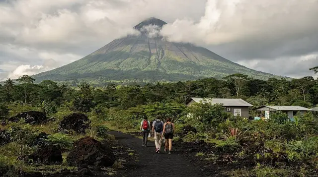
The terrain is the whole point. Instead of soil and roots, you’re walking over broken basalt — jagged in places, smoothed by decades of rain and foot traffic in others — with ferns, shrubs, and young trees pushing up through the cracks. It’s a visible, physical demonstration of ecological succession: 58 years is enough for a forest to start reclaiming a lava field, but not enough to hide what’s underneath it. Guides on these trails typically point out where the rock is still bare versus where the first colonising plants have taken hold, and use the walk to explain the 1968 eruption in more detail than a plaque ever could.
Footing needs real attention. This is not a manicured park path — expect loose rock, occasional scrambling over larger boulders, and sections where tree roots and lava rock are tangled together. Closed, sturdy footwear is not optional here the way it might be a suggestion elsewhere; open sandals or worn sneakers are a genuine twisted-ankle risk on this particular surface.
Guided or self-guided
Policy differs by reserve and by season, so check what you’re booking rather than assuming. In general:
- Guided tours include an English- or Spanish-speaking naturalist guide who explains the 1968 eruption, points out wildlife (this area sees monkeys, coatis, and a range of birds, though sightings aren’t guaranteed), and manages timing around cloud cover for cone views.
- Self-guided entry, where offered, is cheaper but means you’re navigating and interpreting the site on your own, with signage doing most of the explaining.
For a first visit, a guided walk is worth the extra cost — the history is a large part of what makes this hike distinct from any other forest trail near La Fortuna, and a guide is what actually delivers it.
Book a guided walk across the 1968 lava trailSome operators bundle the lava trail into a longer day that also includes the nearby El Silencio sector or a separate hanging bridge circuit — useful if you’d rather combine two short activities than arrange transport twice.
Compare a guided El Silencio trail hikeBest time of day, and what “views of the volcano” really means
The cone is frequently in cloud, at any time of year, and no operator can promise otherwise. What tends to improve the odds:
- Early morning (roughly 6–9am) is generally the clearest window, before afternoon cloud builds up over the volcano.
- Dry season (December–April) gives more consistently clear mornings than green season, though even then the summit can sit in cloud for days at a stretch.
- Green season (May–November) mornings are hit-or-miss — some are perfectly clear, others socked in from sunrise. The trade-off is a much quieter trail and lusher, greener forest cover on the lava field itself.
Book the earliest available slot if a clear cone view matters to you, and treat it as a bonus rather than the reason for going. The lava field, the forest regrowth, and the history are worth the visit even under a grey sky — the volcano view is the part that’s out of anyone’s control.
Combining the 1968 trail with the rest of your day
The 1968 trail sits close enough to several other short activities that a lot of visitors stack two into one morning or afternoon:
- Hanging bridges. Several bridge parks operate near the same base of the volcano; they are separate businesses from the 1968 trail reserves, with their own tickets and trail networks. If you’re deciding between them, our comparison of the different hanging bridge parks breaks down which is which.
- Arenal Observatory Lodge. Higher up the flank, with its own longer trails and some of the best distant cone views in the area — a different kind of hike from the lava field walk. See the Observatory Lodge trails guide for how it compares.
- A hot spring soak afterward. After a couple of hours over uneven lava rock, several visitors head straight to a hot spring to unwind — see our comparison of La Fortuna’s hot spring options, including the free river alternative at Choyín.
- El Castillo. The small village near several of these reserves has its own quieter pace, worth a stop; see the El Castillo destination page.
Multi-activity packages exist that bundle the lava trail with a second stop, generally at a lower combined price than booking each separately.
See the two-day Arenal trails experience Book a guided hike and lava field tour with a local guideWhat to bring
- Closed, sturdy shoes — trail runners or light hiking shoes, not sandals. The lava rock surface is unforgiving on exposed toes and ankles.
- Rain layer, even in dry season. La Fortuna sits on the windward side of the mountains and gets rain year-round; a light waterproof shell packs small and covers most surprises.
- Water and a hat. Shade is partial on much of the flow, and the walk, while short, is active.
- Insect repellent. Standard for any forested trail in this region.
- A charged phone or camera, kept accessible — the lava-field terrain and any cone view that appears are the two things worth photographing here, and both can be brief.
Who this hike suits, and who it doesn’t
It suits visitors who want a moderate, forest-and-rock walk with genuine geological and historical interest, rather than a summit push or an adrenaline activity. It’s a reasonable choice for families with older children who can manage uneven footing, and for anyone whose schedule only allows a single morning near the volcano and wants that time to include both nature and the 1968 story specifically.
It suits less well anyone expecting a strenuous climb, a guaranteed volcano view, or — worth repeating — any chance of seeing lava; none of those are what this trail delivers. If a summit-style hike with a lagoon at the end is what you’re after, that used to be Cerro Chato, but it’s been closed since 2018 for erosion and safety reasons; see why, and what changed if you were planning around it.
For a broader sense of how this fits into a first visit to the area, our guide to how many days to spend in La Fortuna and the best time of year to visit both cover where a lava-trail morning tends to slot in. If you’re building out a single day around the volcano specifically, see one day in La Fortuna, and for the wider set of volcano-focused activities, browse volcano hikes near La Fortuna or everything happening at Arenal itself.
Check availability for a guided Arenal volcano hike
Last but not least, if the “will I see lava” question is still nagging at you, it’s worth reading straight through — the honest answer, and why so many older write-ups still imply otherwise, in the lava lie about Arenal.
Frequently asked questions about the 1968 lava trail
Is the 1968 trail inside Arenal Volcano National Park?
No. The 1968 trail sits on private reserve land adjoining the park’s western side, on the ground actually destroyed by the 1968 eruption. The national park’s own official trails are in the separate Peninsula sector, with their own entrance and ticket.
Will I see lava on the 1968 trail?
No. Arenal’s last eruptive activity was in October 2010, and there has been no visible lava since. What you walk across is solidified basalt rock from 1968, now colonised by ferns, shrubs, and pioneer forest.
How long is the hike and how hard is it?
Most loops on the 1968 lava field cover 2 to 4 km and take 1.5 to 3 hours at an easy pace, with mostly gentle grades and short, rockier climbs over old flow ridges. It suits most fitness levels but the surface is uneven, so ankle-supportive shoes matter more than raw endurance.
Can I do this hike on my own, or do I need a guide?
Some reserves sell self-guided entry, others require a guide, and this changes by operator and season. A guided visit costs more but adds wildlife spotting and the eruption’s history, which is easy to miss on a self-guided walk across what otherwise just looks like rocky scrubland.
What’s the difference between this trail and Cerro Chato?
They’re unrelated hikes on the same volcano. The 1968 trail is a flat-to-rolling walk over old lava at the base of Arenal; Cerro Chato was a steep climb to a neighbouring crater lagoon, and it has been closed to hikers since 2018.
When is the best time to see the volcano’s cone from the trail?
Early morning, generally before 9am, gives the best odds of a cloud-free cone, especially in dry season from December to April. Afternoon cloud builds most days, and green-season mornings (May to November) are hit-or-miss, so treat any clear view as a bonus rather than a guarantee.
How does this compare to the Arenal Observatory Lodge trails?
The Observatory Lodge trails sit higher up, closer to the old lookout point, with longer approaches and some of the best distant cone views in the area. The 1968 trail is lower, shorter, and focused specifically on walking through the lava field itself rather than viewing the cone from a distance.
Volcano hikes on GetYourGuide
Verified deep-linked GetYourGuide tours. Book through these links and we earn a small commission at no cost to you.
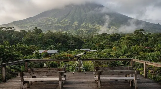
GetYourGuide does not provide a product photo for this activity — the image shows the meeting point, photographed by us.