A village that exists because the old one is underwater
Nuevo Arenal is easy to misread. The name suggests continuity — a place that has always been here, watching the volcano from across the water. It hasn’t. When the Arenal Dam closed in 1979, the lake it created rose over the original village of Arenal and the nearby settlement of Tronadora. Both were relocated before the flooding, their residents moving uphill to build again.
What stands today on the lake’s north shore is that rebuilt town: newer roads, a newer church, a town square laid out from scratch rather than one that grew over a century. Tronadora was rebuilt separately, a short distance away. If you’re picturing colonial streets and a church that has watched the water rise for generations, that’s not this place — and it isn’t meant to be.
That distinction matters more than it might seem, because guidebooks and drivers alike sometimes wave a hand toward Nuevo Arenal and call it “the old lake village,” which flattens a genuinely interesting story into a wrong one. The real story is about displacement and adaptation: a community that lost its homes to a national infrastructure project — the dam still supplies a meaningful share of Costa Rica’s electricity — and rebuilt on the shore of the very lake that swallowed the original. It’s worth knowing before you arrive, because it changes what you’re actually looking at.
What’s here now
Nuevo Arenal today is a small, functional town: a central park, a Catholic church, a soccer field, a cluster of sodas and cafés, and a highway-facing strip of small businesses that serves both residents and the steady trickle of travellers doing the north shore drive. It isn’t dressed up for tourism the way La Fortuna’s town centre is — there’s no equivalent of a nightly street-food scene or a park lined with tour desks. What you get instead is a working village with lake views from its higher streets and a noticeably international mix of residents, drawn over the decades by the cooler climate and cheaper land than around the volcano side.
For most visitors, Nuevo Arenal functions as a waypoint rather than a headline stop. It sits on the road between El Castillo and Arenal Volcano National Park on one side, and Tilarán on the other — the same road that eventually connects, less directly, toward Monteverde by land. If you’re driving that loop, or heading to the western end of the lake for a specific reason, Nuevo Arenal is a natural place to break the trip: stretch your legs, get a coffee, look at the water from a different angle than you get around La Fortuna.
The lake, seen from the quieter side
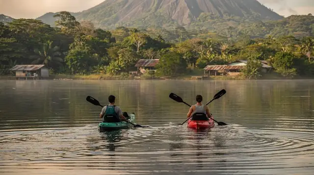
The appeal of stopping here isn’t really the town itself — it’s the lake. Lake Arenal covers roughly 85 square kilometres, and the view changes considerably depending on which shore you’re standing on. Near La Fortuna and the dam, the water sits close under the volcano’s eastern flank. On the north shore near Nuevo Arenal, you get a wider, calmer stretch of water with the volcano further off in the frame — often a better angle for photos when the cone is out from behind cloud, since you’re looking at it across open water rather than up through forest canopy.
Mornings are consistently the best time to be on or near the water here. Wind off the lake tends to build through the day, which is exactly why the eastern end near the dam has become one of the best windsurfing and kitesurfing spots in Central America — but that same wind chops up the water and flattens the light for anyone hoping for a still, mirror-like lake. Arrive before mid-morning if a calm reflection is what you’re after.
Kayaking and birdwatching, done right here
The coves and inlets near Nuevo Arenal are quieter and more sheltered than the open water further east, which makes this stretch of shoreline better suited to kayaking than the areas closer to La Fortuna. Paddling out early, before the wind picks up, is the standard local advice — and it’s advice worth following rather than skipping, since a mid-afternoon crossing on choppy water is a different (and less pleasant) experience than the calm one most people picture.
The mixed shoreline habitat — pasture, secondary forest, and open water — also makes this part of the lake decent for casual birdwatching, particularly waterbirds and raptors working the shoreline. It won’t rival the cloud forest species list you’d get around Monteverde, but for a stop that isn’t primarily a wildlife destination, it delivers more than expected if you’re paying attention with binoculars rather than driving straight through.
Getting here, and where it fits on a trip
The drive from La Fortuna along Route 142 takes roughly 45 minutes to an hour, paved the entire way but narrow and winding, with several one-lane bridges where the vehicle facing the CEDA EL PASO sign yields. It’s a slower road than the distance implies — budget the time rather than rushing it, especially if you’re stopping for photos, which most drivers do at least once along this stretch.
Nuevo Arenal is not, on its own, a reason to restructure a short La Fortuna itinerary. It earns its place as part of a longer day: a loop around the lake, a drive toward Tilarán and beyond, or a stop en route somewhere else on the north shore. If your only plan is Lake Arenal and volcano activities, you can reasonably skip it. If you have a rental car and enjoy the drive itself, it’s a natural, low-pressure addition.
It’s also worth being clear about what Nuevo Arenal is not: it is not the jeep-boat-jeep crossing point to Monteverde — that route uses a different landing on the lake — and it is not the dam itself, which sits at the eastern end near La Fortuna. Nuevo Arenal, the dam, and the boat crossing are three separate stops that get mentally merged by travellers skimming an itinerary quickly. They’re related by geography, not identical.
| Getting to Nuevo Arenal | Time | Notes |
|---|---|---|
| From La Fortuna (Route 142, north shore) | 45–60 min | Paved, narrow, one-lane bridges |
| From Tilarán | 20–30 min | Continues along the same shore road |
| From the Arenal Dam | 30–40 min | Same road, further west |
| Via jeep-boat-jeep landing to Monteverde | Not the same route | Boat departs from a different lake access point |
What to do around a Nuevo Arenal stop
Most travellers combine a Nuevo Arenal stop with an activity elsewhere on the lake rather than booking something in the village itself, since the town’s own offering is limited to cafés, a small market, and the view. A few ways to build a fuller day around it:
If you want to add adventure closer to the north shore rather than driving all the way back to La Fortuna, a zipline circuit run out of Nuevo Arenal is one of the few activities based directly in this part of the lake, saving a return drive.
For a different pace after dark, a guided night walk near Nuevo Arenal covers similar wildlife-spotting ground to the better-known night tours around La Fortuna, without the drive back east.
If Monteverde is on the itinerary and you’re weighing the road option through this side of the lake against the boat crossing, a Monteverde hanging bridges and sloth-spotting tour at Selvatura is worth booking ahead either way, since the reserves cap daily numbers.
And if you’d rather loop back toward the volcano side and end the day soaking rather than driving, a Baldi Hot Springs day pass near La Fortuna is a reasonable way to close out a north-shore day trip.
What Nuevo Arenal isn’t good for
Set expectations honestly: this is not a beach town, not a nightlife town, and not a place to base a multi-day stay unless quiet lakeside living is specifically what you’re after. Restaurant options are limited compared to La Fortuna or Monteverde, and after dark the town is genuinely quiet — which some travellers love and others find underwhelming after a day of driving. If you’re looking for the region’s biggest attractions — the waterfall, the hanging bridges, the volcano trails — those are all back on the La Fortuna side, not here.
It’s also not the place to chase a view of the drowned original village. In most years the old townsite stays fully submerged, and stories of a visible church tower belong to unusually dry, low-water years rather than something you can plan around. Don’t build a stop here around that hope.
Nuevo Arenal, at a glance
| If you’re wondering… | Short answer |
|---|---|
| Is this the historic lake village? | No — rebuilt after the 1979 flood, a few kilometres from the original site |
| Is it worth a special trip? | Only as part of a north shore drive or a lake loop |
| Best time of day to visit? | Morning, before wind picks up over the water |
| Good for kayaking? | Yes — calmer coves than the eastern end of the lake |
| Good base for nightlife or dining? | No — La Fortuna or Monteverde instead |
Frequently asked questions about Nuevo Arenal
Is Nuevo Arenal the original village that used to be here?
No. The original village of Arenal was flooded in 1979 when the dam closed and Lake Arenal filled. Nuevo Arenal was built afterwards, on higher ground a few kilometres from the drowned site — it is a reconstruction, not the historic town.
How far is Nuevo Arenal from La Fortuna?
Around 45 to 60 minutes by car along the north shore road, depending on where you’re coming from and how often you stop for viewpoints. It’s a paved but winding road with lake views for most of the drive.
Can you still see the old village under the lake?
Not really. In an unusually dry year, the church tower of the original village has occasionally shown above a very low waterline, but this is rare and not something to plan a trip around. Most years the site stays fully submerged.
Is Nuevo Arenal worth a stop, or just a drive-through?
It’s worth 30 to 60 minutes if you’re already driving the north shore — the town has a handful of cafés, a market, and lake-view pull-offs nearby. It isn’t a destination on its own; treat it as a stop on the way to Tilarán, the dam, or Monteverde by road.
Is Nuevo Arenal a good base for kayaking or birdwatching?
Yes, more so than La Fortuna itself. The north shore has calmer coves and better access points than the eastern end of the lake near the dam, and mornings are usually stiller before the afternoon wind picks up over the water.
Do I need a rental car to visit Nuevo Arenal?
Practically, yes. Public buses run the north shore road but on limited schedules, and taxis from La Fortuna for a round trip add up quickly. Most visitors see Nuevo Arenal as part of a self-driven loop or a private transfer toward Tilarán or Monteverde.
Is the road from La Fortuna to Nuevo Arenal paved?
Yes, the north shore road (Route 142) is paved the whole way, unlike the unpaved sections further on toward Monteverde. It’s narrow and curvy in places with several one-lane bridges, so allow more time than the distance suggests.